My Weekend Trip Through West Virginia (With Photos!)
#1
 10-09-2007 | 08:54 AM

Thread Starter
|
Road Captain
Joined: May 2007
Posts: 646
Likes: 29
From:
I just came back from a great 900 mile weekend trip through the northern part of West Virginia. It was my first real trip on the Blue Potato and I couldn't have been more proud of her. She rode like a dream.
Day 1 (Friday): Cincinnati, OH to Grafton, WV:
Cincinnati isn't known for its good motorcycle roads by any means and I knew I had to get away. I read so many things about the motorcycling in WV that I started planning a trip at the beginning of the week. I used www.motorcycleroads.us (highly recommended, by the way) as my reference for choosing my routes. I wanted to be on as little freeway as possible. I wanted to be in the mountains, to see the trees changing colors, and try out the bike on some twisties. I even bought some boot insoles and a back stabilizer from Walgreens to improve comfort. The insoles felt great. I don't think the back stabilizer made much of a difference. My standards were high. I thought the back stabilizer was going to make it feel like I had a rider backrest on the Sportster. It didn't.
My packing list:
-Tent
-Western Mountaineering Sleeping Bag
-Thermarest Prolite 4 Sleeping Pad
-Toiletries
-Granola bars
-TomTom One GPS on handlebar RAM Mount
-Clothes
-Flip Flops
-Bungee cords
-Tools
-Camera
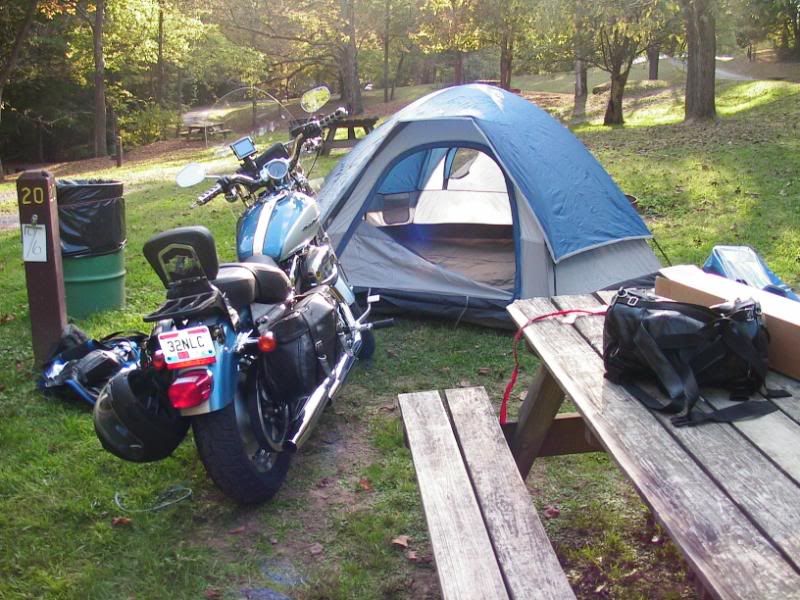
My things were packed in a barrel bag and saddlebags. The tent and my jacket were bungeed to the luggage rack.
The beginning of the route was dull, but past Chillicothe the scenery started to improve, with colorful trees and sweeping turns on rt 50.
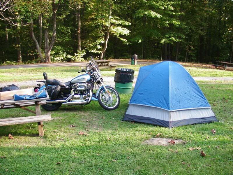
I overnighted at Tygart Lake State Park with plenty of time to set up the tent. Unloading everything took more time than expected and I had to familiarize myself with the new tent. After the tent was up, I did the best I could with the single rag I packed trying to polish some chrome and get the bugs off the headlight, windshield, tank, and AC cover.
Day 2 (Saturday): Grafton, OH to Weston, WV
I woke with dew all over the tent's rain cover (thankfully none inside) and the bike was drenched in dew also. The rag, which I had wet the night before to get the bugs off, hadn't dried, so trying to wipe the moisture off the seat was a failing effort. I came to grips with the fact that I'd have to sit on a wet seat to start the day. Also, the saddlebags and helmet (which I had locked to the bike) were all wet with dew. Lesson learned = take the saddlebags and helmet into the tent at night.
Taking down the tent, rolling my sleeping bag and pad, and packing the bike took 45 minutes and I was on the road by 8:00. As it was foggy and early morning, I knew deer were a danger. Sure enough as I was leaving the state park, there was a deer in the left lane of the road. I stopped completely and scanned to my left and right for his companions. Not seeing any, I pulled ahead with caution.
Now a lot of HD riders scoff at GPS because they deter "adventure." I disagree. If I didn't have a GPS, I would have taken the same route out of the park that I took in the prior day. The GPS notified me of a turn 400 yards away. When I came to the turn, it was on a gravel road not much wider than one car and steep uphill. I knew I had to take it for the sense of adventure and prayed the bike would stay "rubber side down and shiny side up." I remembered to keep my feet out and not use the front brake. It was okay going uphill (where I stopped for a few photos), but downhill was difficult since I had to keep my right foot on the brake. I would prefer mid controls over forwards on
Day 1 (Friday): Cincinnati, OH to Grafton, WV:
Cincinnati isn't known for its good motorcycle roads by any means and I knew I had to get away. I read so many things about the motorcycling in WV that I started planning a trip at the beginning of the week. I used www.motorcycleroads.us (highly recommended, by the way) as my reference for choosing my routes. I wanted to be on as little freeway as possible. I wanted to be in the mountains, to see the trees changing colors, and try out the bike on some twisties. I even bought some boot insoles and a back stabilizer from Walgreens to improve comfort. The insoles felt great. I don't think the back stabilizer made much of a difference. My standards were high. I thought the back stabilizer was going to make it feel like I had a rider backrest on the Sportster. It didn't.
My packing list:
-Tent
-Western Mountaineering Sleeping Bag
-Thermarest Prolite 4 Sleeping Pad
-Toiletries
-Granola bars
-TomTom One GPS on handlebar RAM Mount
-Clothes
-Flip Flops
-Bungee cords
-Tools
-Camera
My things were packed in a barrel bag and saddlebags. The tent and my jacket were bungeed to the luggage rack.
The beginning of the route was dull, but past Chillicothe the scenery started to improve, with colorful trees and sweeping turns on rt 50.
I overnighted at Tygart Lake State Park with plenty of time to set up the tent. Unloading everything took more time than expected and I had to familiarize myself with the new tent. After the tent was up, I did the best I could with the single rag I packed trying to polish some chrome and get the bugs off the headlight, windshield, tank, and AC cover.
Day 2 (Saturday): Grafton, OH to Weston, WV
I woke with dew all over the tent's rain cover (thankfully none inside) and the bike was drenched in dew also. The rag, which I had wet the night before to get the bugs off, hadn't dried, so trying to wipe the moisture off the seat was a failing effort. I came to grips with the fact that I'd have to sit on a wet seat to start the day. Also, the saddlebags and helmet (which I had locked to the bike) were all wet with dew. Lesson learned = take the saddlebags and helmet into the tent at night.
Taking down the tent, rolling my sleeping bag and pad, and packing the bike took 45 minutes and I was on the road by 8:00. As it was foggy and early morning, I knew deer were a danger. Sure enough as I was leaving the state park, there was a deer in the left lane of the road. I stopped completely and scanned to my left and right for his companions. Not seeing any, I pulled ahead with caution.
Now a lot of HD riders scoff at GPS because they deter "adventure." I disagree. If I didn't have a GPS, I would have taken the same route out of the park that I took in the prior day. The GPS notified me of a turn 400 yards away. When I came to the turn, it was on a gravel road not much wider than one car and steep uphill. I knew I had to take it for the sense of adventure and prayed the bike would stay "rubber side down and shiny side up." I remembered to keep my feet out and not use the front brake. It was okay going uphill (where I stopped for a few photos), but downhill was difficult since I had to keep my right foot on the brake. I would prefer mid controls over forwards on
#4
10-09-2007 | 11:46 AM

Banned
Joined: Aug 2006
Posts: 6,642
Likes: 0
From: Fairfax County, Va.
#5
10-09-2007 | 11:55 AM
Road Master
Joined: Oct 2006
Posts: 832
Likes: 5
From: Vermont
Very nice trip report and good photos. There sure are a lot of great twisty two laners to enjoy in WV. You learned quickly what things you needed to keep protected from the dew, eh? I carry a micro-fleece towel with me when I’m camping. It’s very absorbent and dries quickly if packed so air can get at it. I also find a GPS is very handy on a back road tour. Here’s some ideas to consider on your southern tour of the state. One don’t miss is the New River Gorge Bridge on Rte 19 north of Beckley. Stop at the bridge visitor’s center for a great view of the bridge and gorge. Rte 3 between Rte 119 and Glen Daniel is a great stretch. We took Rte 19 north (Rte 41 was recommended but you have to backtrack to the bridge). Rte 60 east and Rte 20 north take you to Rte 39 east which is another good stretch. If you ride Rte 39, be sure to take Rte 150, the Highland Scenic Highway. It’s not curvy but the views are as good as many along the Blue Ridge Parkway. We kept going north on Rte 55/219 so I don’t have a good way to loop back but I’m sure Rte 219 south would be good. The stop at the National Radio Astronomy Observatory was interesting but not as outstanding as I thought it would be. Rte 66 past Snowshoe ski resort and through Cass was more fun than the stop at the observatory. I don’t mean to highjack your thread but thought you might like some ideas as you plan a southern route.
#6
10-09-2007 | 03:44 PM
Thread Starter
|
Road Captain
Joined: May 2007
Posts: 646
Likes: 29
From:
ORIGINAL: Woodchuck
Very nice trip report and good photos. There sure are a lot of great twisty two laners to enjoy in WV. You learned quickly what things you needed to keep protected from the dew, eh? I carry a micro-fleece towel with me when I’m camping. It’s very absorbent and dries quickly if packed so air can get at it. I also find a GPS is very handy on a back road tour. Here’s some ideas to consider on your southern tour of the state. One don’t miss is the New River Gorge Bridge on Rte 19 north of Beckley. Stop at the bridge visitor’s center for a great view of the bridge and gorge. Rte 3 between Rte 119 and Glen Daniel is a great stretch. We took Rte 19 north (Rte 41 was recommended but you have to backtrack to the bridge). Rte 60 east and Rte 20 north take you to Rte 39 east which is another good stretch. If you ride Rte 39, be sure to take Rte 150, the Highland Scenic Highway. It’s not curvy but the views are as good as many along the Blue Ridge Parkway. We kept going north on Rte 55/219 so I don’t have a good way to loop back but I’m sure Rte 219 south would be good. The stop at the National Radio Astronomy Observatory was interesting but not as outstanding as I thought it would be. Rte 66 past Snowshoe ski resort and through Cass was more fun than the stop at the observatory. I don’t mean to highjack your thread but thought you might like some ideas as you plan a southern route.
Very nice trip report and good photos. There sure are a lot of great twisty two laners to enjoy in WV. You learned quickly what things you needed to keep protected from the dew, eh? I carry a micro-fleece towel with me when I’m camping. It’s very absorbent and dries quickly if packed so air can get at it. I also find a GPS is very handy on a back road tour. Here’s some ideas to consider on your southern tour of the state. One don’t miss is the New River Gorge Bridge on Rte 19 north of Beckley. Stop at the bridge visitor’s center for a great view of the bridge and gorge. Rte 3 between Rte 119 and Glen Daniel is a great stretch. We took Rte 19 north (Rte 41 was recommended but you have to backtrack to the bridge). Rte 60 east and Rte 20 north take you to Rte 39 east which is another good stretch. If you ride Rte 39, be sure to take Rte 150, the Highland Scenic Highway. It’s not curvy but the views are as good as many along the Blue Ridge Parkway. We kept going north on Rte 55/219 so I don’t have a good way to loop back but I’m sure Rte 219 south would be good. The stop at the National Radio Astronomy Observatory was interesting but not as outstanding as I thought it would be. Rte 66 past Snowshoe ski resort and through Cass was more fun than the stop at the observatory. I don’t mean to highjack your thread but thought you might like some ideas as you plan a southern route.
That's great advice. I value your information a lot and will use it as my base for planning the Southern WV trip. Your description makes me want to throw the tent back on the bike and head out tomorrow!.
#7
10-11-2007 | 12:44 PM

Account Retired
Joined: Feb 2006
Posts: 2,448
Likes: 8
From: On Parole - Grays Creek, North Carolina
Trending Topics

#10
11-15-2007 | 03:25 PM

Tourer
Joined: Sep 2006
Posts: 363
Likes: 2
From: Virginia
We make the Seneca Rocks trip about twice a year. Beautiful.We have alot of good roads to ride. It seems like we get tired of riding them and are always looking for new places to go. One Sunday morning-went to Winchester-took Rt 50 West-turned up to Deep Creek Lake, Md. Went on thru Accident Md. Took Interstate. Came down to Berkley Springs and back to Winchester on Rt 522. Great ride.