
Best Riding in California?
#11
 02-11-2010, 04:41 PM

Cruiser
+1 to Biggzed.
An hour of of SF on the way to Yosemite, there's a thing called the "Sierra Dinner Train" http://www.sierrarailroad.com/dinnertrain/
They also have a neat over-all look, as there is a train out of Ft Bragg, on the Coast north of SF: http://www.sierrarailroad.com/
Keep Norther California green: Spend money $$$$
#12
02-11-2010, 04:54 PM
North is better in August - daytime temps in Fresno will be 100+, sometimes 110+, and it doesn't cool down much at night. Yosemite is very crowded and surrounded by desert heat. And the critters come out at night....
The redwoods are spectacular. http://redwoods.info/ One of our very favorite places to ride.
The redwoods are spectacular. http://redwoods.info/ One of our very favorite places to ride.
#13
02-11-2010, 05:11 PM

#14
02-11-2010, 09:01 PM
Road Captain
#15
02-11-2010, 11:17 PM

Cruiser
Join Date: Nov 2009
Location: Sunny California
Posts: 113
Likes: 0
Received 0 Likes
on
0 Posts
Zach's route is pretty good. Highway 36 is awesome. Pit stops along the Redwoods, Big Sur, Morro Bay, Tahoe....all picturesque.
Speaking of pictures...took this one near the east entrance to Hwy 36.
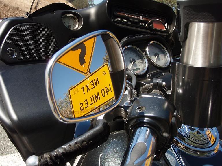
Speaking of pictures...took this one near the east entrance to Hwy 36.
I would recommend going north out of San Francisco. Take the Golden Gate bridge out of town. You can either take Hwy 1 or 101. Like was said earlier, Hwy 1 is two lane the whole way and can be VERY busy and SLOW. Lots of very cool little towns along Hwy 1 though.
If you take 101 after crossing the Golden Gate you will still see some beautiful country and you can make better time.
I would take 101 to Willits, then head west on Hwy 20 (fun and twisty road). This will end at the ocean in a little town called Fort Bragg. Very cool little town. From Fort Bragg, head north on 1. It will dead-end back into 101 at Leggett. There is a drive through Redwood tree in Leggett which is fun for a little stop. The road is very twisty up to Leggett, so you might want to get off for a few minutes anyway.
From there take 101 north. There are some cool little towns along the way like Garberville. Make sure to take The Avenue of the Giants and see some incredibly old and huge Redwoods. From there, I would probably head back east at Hwy 299 just north of Eureka/Arcata. Stop in the town of Weaverville and grab something to eat or drink. Then take Hwy 3 north and enjoy some beautiful mountain twists and turns. Hwy 3 will take you back toward I-5 where you can stop in the town of Mt Shasta. Eat a great Mexican dinner at Casa Ramos. Be careful of the fish bowl Margaritas.
From there you would have a beautiful ride back to Reno via:
Hwy 89 east to Hwy 44 east (this will take you right by Mt Lassen)
Hwy 44 east to Hwy 36 east
Hwy 36 east to Hwy 395 south right into Reno
Just my .02
Zach
#16
02-11-2010, 11:51 PM

Road Warrior
Time Mile Instruction For Toward
Summary: 845.0 miles (1 day, 7 hours, 35 minutes)
DAY 1
9:00 AM 0.0 Depart Reno on Mill St (East) 1.6 mi
9:03 AM 1.6 Keep RIGHT onto Local road(s) 153 yds US-395
9:04 AM 1.7 Take Ramp onto US-395 8.5 mi
9:11 AM 10.1 At exit 57B, keep RIGHT onto Ramp 0.6 mi US-395 / Virginia City / Carson City / So Lake Tahoe
9:12 AM 10.7 Keep STRAIGHT onto US-395 17.1 mi
9:30 AM 27.8 At exit 43, keep LEFT onto Ramp 0.7 mi US-395 Business / N Carson St
9:31 AM 28.5 Bear RIGHT (South) onto US-395 [N Carson St] 2.6 mi
9:36 AM 31.1 At Carson City, stay on US-395 [US-50] (South) 4.4 mi
9:42 AM 35.5 Turn RIGHT (West) onto SR-206 [Jacks Valley Rd] 8.3 mi
9:54 AM 43.8 Keep STRAIGHT onto SR-206 [Main St] 0.3 mi
9:54 AM 44.0 Turn RIGHT (West) onto Nixon St 174 yds
9:55 AM 44.1 At Genoa, return East on Nixon St 174 yds
9:55 AM 44.2 Turn RIGHT (South) onto SR-206 [Main St] 1.7 mi
9:59 AM 46.0 Keep STRAIGHT onto SR-206 [Foothill Rd] 1.2 mi
10:01 AM 47.2 Turn RIGHT (West) onto Local road(s) 2.4 mi
10:04 AM 49.5 Turn RIGHT (East) onto SR-207 7.1 mi
10:14 AM 56.6 Turn LEFT (South) onto US-50 [Lake Tahoe Blvd] 5.7 mi
10:15 AM 57.3 Entering California
10:23 AM 62.3 Keep STRAIGHT onto Lake Tahoe Blvd 0.2 mi
10:24 AM 62.5 Turn LEFT (South) onto Tata Ln 164 yds
10:25 AM 62.6 At South Lake Tahoe, stay on Tata Ln (South-East) 0.6 mi
10:27 AM 63.2 Turn LEFT (East) onto F St 0.2 mi
10:27 AM 63.4 Turn RIGHT (South) onto US-50 [SR-89] 4.1 mi
10:34 AM 67.5 Turn LEFT (South) onto SR-89 [Luther Pass Rd] 11.2 mi
10:48 AM 78.7 Turn LEFT (East) onto SR-88 [SR-89] 5.8 mi
10:55 AM 84.5 Turn RIGHT (South-East) onto SR-89 6.4 mi
11:03 AM 90.9 At Markleeville, stay on SR-89 (South-East) 4.9 mi
11:09 AM 95.8 Turn LEFT to stay on SR-89 17.6 mi
11:30 AM 113.4 Turn LEFT (North) onto US-395 4.1 mi
11:34 AM 116.8 Entering Nevada
11:35 AM 117.5 At Topaz Lake, return South on US-395 [US Highway 395 S] 44.6 mi
11:35 AM 118.1 Entering California
12:18 PM 162.0 At Bridgeport, stay on US-395 [Main St] (East) 25.8 mi
12:42 PM 187.8 Keep RIGHT onto Local road(s) 98 yds
12:43 PM 187.9 Bear RIGHT (South) onto SR-120 [Tioga Pass Rd] 32.8 mi
1:26 PM 220.7 Turn RIGHT (North) onto Local road(s) 2.0 mi
1:32 PM 222.7 At Yosemite National Park, return South on Local road(s) 2.0 mi
1:38 PM 224.7 Turn RIGHT (West) onto SR-120 [Tioga Pass Rd] 25.8 mi
2:12 PM 250.5 Turn LEFT (East) onto Big Oak Flat Rd 9.5 mi
2:27 PM 260.0 Turn RIGHT (West) onto SR-140 [Yosemite All-Year Hwy] 36.8 mi
3:11 PM 296.8 At Mariposa Lodge, stay on SR-140 [SR-49] (North-West) 0.6 mi
3:12 PM 297.4 Turn LEFT (West) onto SR-49 36.5 mi
3:56 PM 333.9 Turn LEFT (West) onto SR-120 [SR-49] 8.4 mi
4:04 PM 342.3 Keep RIGHT onto SR-49 [Montezuma Rd] 3.4 mi
4:07 PM 345.7 Bear RIGHT (North-East) onto SR-108 [SR-49] 3.2 mi
4:11 PM 348.9 Turn LEFT (West) onto CR-E5 [Rawhide Rd] 4.0 mi
4:18 PM 352.9 Turn LEFT (West) onto SR-49 9.8 mi
4:29 PM 362.7 Keep STRAIGHT onto SR-4 [SR-49] 1.5 mi
4:32 PM 364.2 Keep STRAIGHT onto SR-49 [N Main St] 11.8 mi
4:46 PM 376.0 Keep RIGHT onto Local road(s) 109 yds
4:46 PM 376.0 Keep STRAIGHT onto SR-49 14.3 mi
5:03 PM 390.4 Arrive Jackson
End of day
DAY 2
9:00 AM 390.4 Depart Jackson on SR-49 [SR-88] (North-West) 1.9 mi
9:02 AM 392.3 Keep STRAIGHT onto SR-88 1.5 mi
9:04 AM 393.8 Keep STRAIGHT onto SR-104 [SR-88] 5.3 mi
9:09 AM 399.1 Keep STRAIGHT onto SR-88 13.6 mi
9:23 AM 412.7 Keep RIGHT onto Local road(s) 98 yds
9:23 AM 412.8 Bear RIGHT (West) onto SR-12 [SR-88] 6.9 mi
9:31 AM 419.7 Keep STRAIGHT onto SR-88 12.3 mi
9:44 AM 432.0 Take Ramp (RIGHT) onto SR-99 1.2 mi CA-99 / Los Angeles
9:46 AM 433.2 Road name changes to SR-26 [SR-99] 0.3 mi
9:46 AM 433.6 Take Ramp (RIGHT) onto SR-4 [Ort Lofthus Fwy] 3.0 mi CA-4 / I-5 / Downtown Stockton / San Francisco
9:49 AM 436.5 Turn RIGHT onto Ramp 0.3 mi I-5 / San Francisco / Los Angeles
9:49 AM 436.8 Take Ramp (RIGHT) onto I-5 [SR-4] 13.5 mi I-5 / CA-4 / San Francisco / Los Angeles
10:01 AM 450.4 At exit 458B, take Ramp (RIGHT) onto I-205 14.0 mi I-205 / I-580 / San Francisco
10:13 AM 464.4 Merge onto I-580 19.4 mi
10:29 AM 483.8 Turn RIGHT onto Ramp 0.3 mi I-680 / Sacramento / San Jose
10:30 AM 484.0 Keep LEFT to stay on Ramp 0.2 mi I-680 / San Jose
10:30 AM 484.2 Take Ramp (RIGHT) onto I-680 [Sinclair Fwy] 17.1 mi I-680 / San Jose
10:45 AM 501.3 Turn RIGHT onto Ramp 0.2 mi Mission Blvd / I-880 / Warm Springs Dist
10:45 AM 501.5 Take Ramp (RIGHT) onto SR-262 [Mission Blvd] 1.1 mi Mission Blvd West / I-880 / Warm Springs District / Uc Extension
10:47 AM 502.6 Turn LEFT onto Ramp 0.3 mi I-880 / San Jose
10:47 AM 502.9 Take Ramp (LEFT) onto I-880 [Nimitz Fwy] 12.4 mi I-880 / San Jose
10:58 AM 515.4 Road name changes to SR-17 6.6 mi
11:04 AM 522.0 Take Ramp (RIGHT) onto SR-9 [Los Gatos Saratoga Rd] 0.4 mi CA-9 / Los Gatos / Saratoga / Monte Sereno
11:04 AM 522.4 Turn LEFT (South) onto University Ave 0.5 mi
11:06 AM 522.9 Turn LEFT (East) onto (W) Main St 0.2 mi
11:08 AM 523.1 At Los Gatos, stay on E Main St (West) 0.3 mi
11:09 AM 523.5 Turn LEFT (South) onto S Santa Cruz Ave 0.2 mi
11:10 AM 523.7 Take Ramp (RIGHT) onto SR-17 18.9 mi CA-17 / Santa Cruz
11:31 AM 542.6 Road name changes to SR-1 [SR-17] 1.2 mi
11:32 AM 543.8 Keep LEFT onto SR-1 [Cabrillo Hwy] 54 yds
11:32 AM 543.8 Keep STRAIGHT onto Chestnut St 0.2 mi
11:33 AM 544.0 At Santa Cruz, stay on Chestnut St (North) 0.2 mi
11:33 AM 544.2 Turn LEFT (South-West) onto SR-1 [Mission St] 33.0 mi
12:19 PM 577.2 Turn RIGHT (East) onto Pescadero Creek Rd 2.0 mi
12:25 PM 579.2 Turn LEFT (North) onto Stage Rd 43 yds
12:25 PM 579.3 At Duarte's Tavern [202 Stage Rd, Pescadero CA 94060, (650) 879-0464], return South on Stage Rd 43 yds
12:25 PM 579.3 Turn RIGHT (West) onto Pescadero Creek Rd 2.0 mi
12:31 PM 581.3 Turn RIGHT (North) onto SR-1 [Cabrillo Hwy] 14.8 mi
12:48 PM 596.1 Turn RIGHT (East) onto Filbert St 0.2 mi
12:49 PM 596.4 Turn LEFT (North) onto Main St 0.3 mi
12:50 PM 596.7 At Half Moon Bay, stay on Main St (North) 0.3 mi
12:51 PM 597.0 Turn RIGHT (East) onto SR-92 4.9 mi
12:58 PM 602.0 Bear LEFT (North-East) onto SR-35 [SR-92] 2.0 mi
1:00 PM 604.0 Turn LEFT (North-West) onto SR-35 [Skyline Blvd] 0.9 mi
1:01 PM 604.9 Turn RIGHT (East) onto Bunker Hill Dr, then immediately turn LEFT (North) onto Ramp 0.3 mi
1:02 PM 605.2 Merge onto I-280 [Junipero Serra Fwy] 8.2 mi
1:09 PM 613.4 Take Ramp (RIGHT) onto I-380 1.6 mi I-380 / S F Intl Airport
1:10 PM 615.0 Take Ramp (RIGHT) onto US-101 [Bayshore Fwy] 10.2 mi US-101 / San Francisco
1:20 PM 625.2 At exit 433C, keep RIGHT onto Ramp 0.1 mi Ninth St / Civic Center
1:20 PM 625.3 Bear LEFT (North-West) onto 9th St 0.6 mi
1:22 PM 625.9 Road name changes to Hayes St 0.2 mi
1:22 PM 626.1 Turn RIGHT (North) onto US-101 [Van Ness Ave] 0.1 mi
1:23 PM 626.2 At San Francisco, stay on US-101 [Van Ness Ave] (South) 0.2 mi
1:23 PM 626.4 Turn LEFT (East) onto Fell St 0.1 mi
1:23 PM 626.5 Road name changes to 10th St 0.6 mi
1:25 PM 627.1 Turn LEFT (North-East) onto Bryant St 0.2 mi
1:25 PM 627.4 Take Ramp (LEFT) onto I-80 [James Lick Skyway] 8.1 mi I-80 / Oakland
1:35 PM 635.5 Merge onto I-880 0.2 mi
1:35 PM 635.7 Merge onto I-580 [I-80] 3.3 mi
1:38 PM 639.0 Keep LEFT onto I-80 [Eastshore Fwy] 69.5 mi I-80 / Vallejo / Sacramento
2:37 PM 708.5 Take Ramp (RIGHT) onto I-80 135.5 mi I-80 / Reno
4:21 PM 830.9 Entering Nevada
4:32 PM 844.0 At exit 13, turn RIGHT onto Ramp 0.1 mi Downtown Reno / Virginia St
4:32 PM 844.2 Bear LEFT (East) onto Maple St, then immediately turn RIGHT (South) onto US-395 Bus [N Virginia St] 0.8 mi
4:34 PM 844.9 Turn LEFT (East) onto Mill St 54 yds
4:35 PM 845.0 Arrive Reno
#18
02-12-2010, 12:07 AM
Sponsor
My wife and I are planning to do a Fly-n-Ride to the west coast in August (timing not negoitable due to kids being away at camp). Some parts of the trip are definite: flying into Reno, picking-up 2 bikes, spending a day or 2 in the Lake Tahoe area, then ride out to San Francisco to spend a day or 2 with family out there. Then what? The question is, what's THE best riding from there (knowing we need to land-up back in Reno)?
Based on some web-surfing, we thought about heading SOUTH along the coast as far as Morro Bay and then maybe go inland, see Yosemite & mountains as we head back toward Reno.
Someone suggested things were more scenic heading NORTH from San Francisco along the coast and then ride thru wine country on the way back.
We'll probably have ~10 days and would like to stop and see things along our way (not just pressed to ride, ride, RIDE!), so we can't do everything. We might even want to spend a day or 2 at a nice coastal resort for some R&R. What what would those who've been there & know the options recommend?
Lots of great ideas here. Willits/Fort Bragg is a great idea. They have nice train that runs through the mountains.
BUT... BEWARE Southern Cal if blazzing hot in Aug. Central and Northern Cal has a nicer climate. Try Santa Barbara.
Have fun and be safe.
__________________

#19
02-12-2010, 12:17 AM
North is better in August - daytime temps in Fresno will be 100+, sometimes 110+, and it doesn't cool down much at night. Yosemite is very crowded and surrounded by desert heat. And the critters come out at night....
The redwoods are spectacular. http://redwoods.info/ One of our very favorite places to ride.
The redwoods are spectacular. http://redwoods.info/ One of our very favorite places to ride.
Agree, you don't want to be in central Ca. in the middle of summer.
