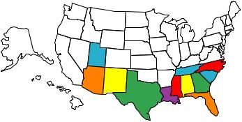
States travelled to!
#22
owned an hd since 94.been on many trips.first one was 6 weeks.rest were one week trips.been on 3 trips with wife.actually rode in utah,colorado, and visited the four courners.so i havent actually rode in new mexico or arizona.so far ive tried staying out of helmet states.that might change since i ahve children now and am contemplating on wearing a helmet.
Last edited by jimmie d wad; 10-14-2009 at 03:08 PM.
#23
<center>
<a href="http://www.mytriplogs.com" target="_blank">
<img src="http://www.mytriplogs.com/sigs/mtl_c...uuuvuvvuuuuuuu" border="0"></img>
<br>Free, personalized travel maps at mytriplogs.com</a>
<br>
</center>
<a href="http://www.mytriplogs.com" target="_blank">
<img src="http://www.mytriplogs.com/sigs/mtl_c...uuuvuvvuuuuuuu" border="0"></img>
<br>Free, personalized travel maps at mytriplogs.com</a>
<br>
</center>
#24
#26
I know I was joking and I'm guessing you were too. Next trip, I'm heading out to Ol' Virginie to confirm.
#28
 .
. I have spent a lot of times in the Virginia mountains and not once has anyone told me I look like a hog. Lots of good riding in Va, NC, TN etc, you should check it out. And remember, if you are concerned about someone thinking you look like a hog, we allow open carry of weapons

#29
If you want to create your own travel map - it is simple with Google charts!

I could go into all the details and configuration options, but the easy way is to simply post the following url just as you would any image. Between image tags [img][/img]
"http://chart.apis.google.com/chart?cht=t&chs=440x220&chd=s:AAAAAAAAAAAAAA&chco= FFFFFF,ff5757,33ccaa&chld=COILIAKSLAMOMTNENMOKSDTX WIWY&chtm=usa&chf=bg,s,E5E4E9"
To make yours look like mine, just add any state abreviation you need following the "chld=" section. (i.e. chld=CO for Colorado).
Also make sure you have the same number of "A's" as you states. It is that simple. You can change the size of your map by adjusting the 440x220 size parameters.
Let me know if you have any questions!
Last edited by bradleys; 10-19-2009 at 11:33 AM.


